News
NASA to map Greenland’s fjords
Lucie Rychla
April 5th, 2016
Share
This article is more than 9 years old.
The aim is to investigate the link between ocean temperatures and melting glaciers
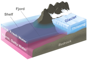
This diagram represents a typical glacier in Greenland. OMG will measure the volume and extent of the warm, salty water layer each year and relate it to the thinning and retreat of the glaciers (photo: NASA)
The US space agency NASA is currently in the process of mapping the seabed in western Greenland as part of the Oceans Melting Greenland mission (OMG).
OMG is a five-year-long project that will pave the way for improved estimates of the rise in sea level and explore the link between ocean temperatures and melting glaciers in Greenland.
Researchers will survey Greenland’s coastal glaciers using a device aboard NASA’s Gulfstream III aircraft. The Glacier and Ice Surface Topography Interferometer can generate high resolution and high precision elevation measurements.
Along with other surveys in the region, this mission will provide improved estimates of the rise in global sea levels.
Share